


(The Center Square) – Erin will miss the southeastern coast, the National Hurricane Center says.
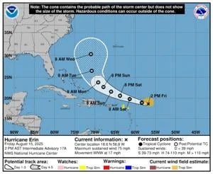
Upgraded from tropical storm to the Atlantic basin’s first hurricane of the season Friday morning, Erin at 2 p.m. Eastern was packing maximum sustained winds of 75 mph – just above the threshold for Category 1. The storm was 415 miles east of the Northern Leeward Islands moving west to northwestward.
“While the threat of direct impacts in the Bahamas and along the East Coast of the United States appears to be gradually decreasing, there will still be significant risk of dangerous surf and rip currents along the western Atlantic beaches next week,” the Hurricane Center said.
Category 4 winds of 111-129 mph are forecast over the fuel-friendly Atlantic Ocean.
A cone of probable tropical storm force winds extended from just off the coastline of Florida to the Outer Banks of North Carolina with a timeline from Monday evening to Tuesday evening. A cone of direction from the Hurricane Center showed the center being at or above 30 degrees longtitude – a point essentially running along the panhandle of Florida – on Wednesday morning at 8 a.m. slightly closer to Bermuda than the Atlantic Seaboard.
The Atlantic hurricane season opened June 1 and runs to Nov. 30. Average formation date for the season’s first is Aug. 11.
Last year, three hurricanes in 66 days landed in Florida. The season’s worst damage was from one of them, Helene, that landed near Dekle Beach, Fla., on Sept. 26 and traveled into western North Carolina on Sept. 27. Helene was Category 4 upon landfall with maximum sustained winds of 140 mph.
The Tarheel State on Friday began its 47th week of recovery from the storm that killed 107 and did an estimated $60 billion damage. Across seven states, Helene killed 236.